The Role of High-Definition Maps in Autonomous Vehicles
1 November 2025
So you're curious about autonomous vehicles—those futuristic, self-driving wonders that are changing the way we move. Pretty fascinating, right? But when we think of autonomous cars, we often focus on their sensors, cameras, and artificial intelligence. What’s often overlooked is one of the biggest unsung heroes of the self-driving revolution: high-definition maps.
Yep, HD maps are kind of like a superpower for autonomous vehicles. They provide way more than just directions from Point A to Point B. These maps allow self-driving cars to make smart, split-second decisions with the kind of confidence that humans can only dream of.
Too dramatic? Not at all. Let's break it down.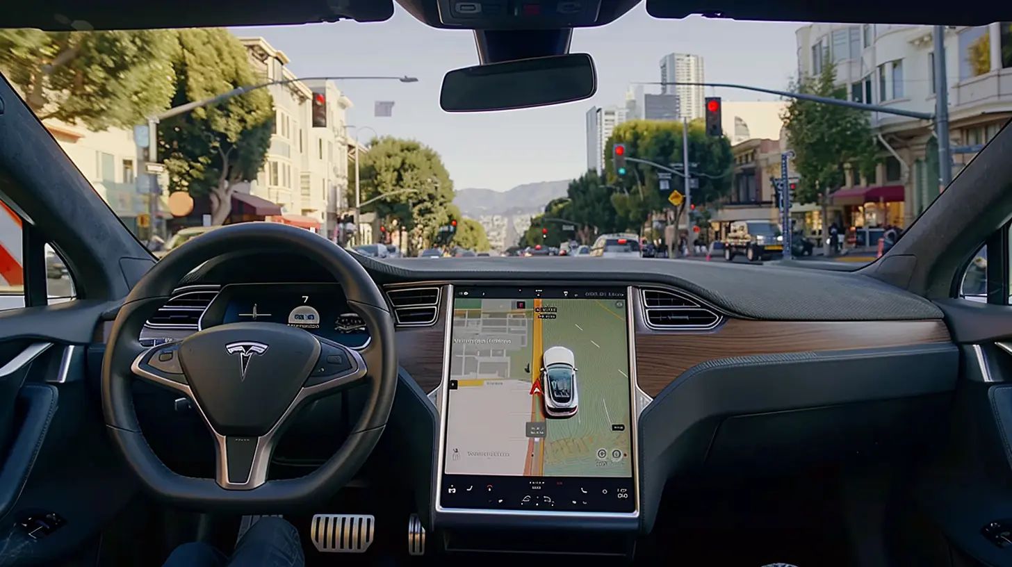
What Are High-Definition Maps Anyway?
When you think of digital maps, you probably picture Google Maps or Apple Maps—great for getting you to your favorite pizza place. But those are just regular-resolution roadmaps. High-definition maps? They're in a whole different league.HD maps provide centimeter-level accuracy. We're talking about ultra-detailed representations of the road that include things like:
- Exact lane boundaries
- Curbs
- Traffic signals and signs
- Pedestrian crossings
- Speed bumps
- Slope and road gradient
- Barriers and guardrails
Imagine driving with superhuman vision and memory. That’s what HD maps provide for autonomous vehicles. These maps give cars the situational awareness to navigate complex traffic environments even when they can’t "see" due to fog, rain, snow, or… surprise roadwork.
Why Can’t Autonomous Vehicles Rely on Sensors Alone?
Great question!Self-driving cars are equipped with all sorts of fancy tech—LiDAR, radar, ultrasonic sensors, and cameras. These gadgets are like the car’s eyes and ears. But here’s the catch: sensors are reactive, not proactive.
Picture this: You’re driving and suddenly there's a construction site or road closure. A human driver might spot it and reroute based on memory or common sense. But a self-driving car? It needs backup. Sensors can detect immediate obstacles, but they don’t know what’s around the corner or two streets away.
That’s where HD maps swoop in to save the day. They offer context and foresight, things no sensor can provide alone.
The Three Key Roles of HD Maps in Autonomous Driving
Let’s dig into the meat of it—how exactly do HD maps help autonomous vehicles? We can break down their role into three vital categories.1. Localization: Knowing Exactly Where the Car Is
This is the biggest game-changer. HD maps provide centimeter-level accuracy to help the car pinpoint its location on the road. GPS? That’s not accurate enough. A few meters off, and your car might think it’s in the left lane when it’s actually in the right one. Oops.HD maps allow the car to match real-time sensor data with map data to determine its exact position. It’s like the car constantly asking, “Where am I?” and getting a pinpoint answer every millisecond.
2. Prediction: Seeing Before Sensing
No, we’re not talking about fortune telling. But HD maps allow autonomous cars to predict what comes next. For instance:- Is the lane about to merge?
- Is there a sharp curve ahead?
- What’s the speed limit three intersections down?
Having this “ahead-of-time” information is crucial for planning safe and smooth routes. It’s like having a really smart co-pilot whispering in your ear, “Slow down, sharp bend ahead.”
3. Redundancy: Acting as a Backup System
You know how pilots have backup systems for almost everything? Same goes for autonomous cars.In bad weather, sensor quality drops. Cameras get blurry, LiDAR gets distorted by rain or snow—basically, things get messy. HD maps act like a clean, reliable backup system, offering the vehicle a “plan B” version of reality to fall back on.
Real-World Applications of HD Maps in Autonomous Driving
You’ve probably heard companies like Waymo, Tesla, and Cruise tossing around the term “HD maps.” These tech giants are using them in real-world autonomous driving tests, and in some cases, commercial applications.For instance:
- Waymo uses detailed HD maps to operate its robotaxi service in Phoenix, AZ. These maps help cars navigate intersections, recognize unmarked roads, and handle roundabouts like a pro.
- Tesla, on the other hand, takes a slightly different approach with its Full Self Driving (FSD) system, relying more heavily on vision and AI. But even Tesla uses mapping data for fleet learning and route optimization.
- Cruise, which operates in San Francisco, leverages HD maps to deal with the city’s unpredictable terrain, angled intersections, and those sneaky cyclists popping out of nowhere.
How Are HD Maps Made?
Creating HD maps is no walk in the park. It’s a massive, data-intensive job that combines various tech tools like:- LiDAR scanning vehicles: These bounce laser beams off surroundings to build 3D models of roads.
- Cameras and sensors: Constantly capturing real-time visuals.
- Drones and aerial imaging: Giving a bird's-eye view for broader context.
- Crowdsourced data: Some companies even use data points from millions of cars (like in Tesla’s fleet) to update their maps.
Once this data is collected, it’s processed and turned into a detailed, semantically rich HD map. Then it has to be kept updated—because roads never stay the same for long.
Construction? Lane closures? New buildings? HD maps must evolve constantly. Some companies are even using AI to automatically detect and update changes in real-time.
Challenges and Limitations of HD Maps
Alright, real talk—HD maps aren’t perfect. There are several speed bumps (pun intended) in the road to full adoption.1. Constant Updates Are a Must
The world isn’t static. Roads change all the time. Keeping HD maps accurate means continual updates, which is labor-intensive and costly.2. High Storage Demands
These maps are huge—several terabytes per city. Storage and data transfer become a big issue, especially for real-time updates.3. Geographical Availability
Most HD maps are available only in areas where autonomous vehicle testing is taking place. Rural or less developed areas? Not so much.4. Privacy Concerns
With so much data being collected, especially through crowd-sourcing, there are valid privacy questions. Where is the line, and how transparent are companies being?The Road Ahead: What’s Next for HD Maps?
As we inch closer to the dream of full Level 5 autonomy (that means no steering wheel, no pedals, no human intervention), HD maps are only going to become more critical.In the future, we could see:
- Global HD Map Coverage
- Real-Time Crowd-Sourced Updates
- Collaborative Mapping Platforms
- AI-Generated Dynamic Maps
Some experts even predict that HD maps will be a key piece in the puzzle for “smart cities,” where autonomous cars, traffic lights, and infrastructure all talk to each other in harmony.
Conclusion: The Unsung Hero Behind the Wheel
So the next time someone marvels at how a self-driving car can change lanes, navigate traffic, and stop at a red light all on its own, let’s give a quiet nod to HD maps. These high-definition supermaps are the guiding hands behind the scenes, making sure autonomous vehicles don’t just drive—but drive safely, efficiently, and smartly.Without them, we'd literally be lost.
all images in this post were generated using AI tools
Category:
Autonomous VehiclesAuthor:

Kira Sanders
Discussion
rate this article
2 comments
Geneva Wilcox
Essential for navigation, safety, and precision.
April 18, 2026 at 3:38 AM
Kira Sanders
Absolutely, high definition maps are crucial for ensuring autonomous vehicles navigate safely and accurately.
Vanta McCarty
Great insights on the critical role high-definition maps play in the development of autonomous vehicles. As technology advances, the integration of precise mapping will undoubtedly enhance navigation accuracy and safety, ultimately bringing us closer to widespread adoption of self-driving cars. Looking forward to more discussions on this topic!
November 2, 2025 at 5:43 AM
Kira Sanders
Thank you for your thoughtful comment! I appreciate your insights and look forward to further discussions on the importance of high-definition maps in advancing autonomous vehicle technology.